Back شتاينهايم (وستفاليا) Arabic اشتاینهایم، وستفالن AZB Штайнгайм (Вестфалія) Byelorussian Штайнхайм (Вестфали) CE Steinheim (lungsod sa Alemanya, Nordrhein-Westfalen, Regierungsbezirk Detmold, lat 51,87, long 9,09) CEB Steinheim (Westfalen) German Steinheim (Vestfalio) Esperanto Steinheim (Westfalia) Spanish Steinheim Basque اشتاینهایم، وستفالن Persian
Steinheim | |
|---|---|
 View of Steinheim with the Catholic Parish Church of Saint Mary | |
 Coat of arms | |
Location of Steinheim within Höxter district 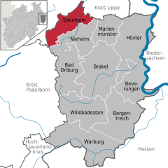 | |
 Steinheim  Steinheim | |
| Coordinates: 51°51′57″N 09°05′40″E / 51.86583°N 9.09444°E | |
| Country | Germany |
| State | North Rhine-Westphalia |
| Admin. region | Detmold |
| District | Höxter |
| Subdivisions | 9 |
| Government | |
| • Mayor (2020–25) | Carsten Torke[1] (CDU) |
| Area | |
| • Total | 75.68 km2 (29.22 sq mi) |
| Elevation | 180 m (590 ft) |
| Population (2023-12-31)[2] | |
| • Total | 12,643 |
| • Density | 170/km2 (430/sq mi) |
| Time zone | UTC+01:00 (CET) |
| • Summer (DST) | UTC+02:00 (CEST) |
| Postal codes | 32839 |
| Dialling codes | 05233 |
| Vehicle registration | HX |
| Website | www.steinheim.de |

Steinheim (Low German: Staime) is a town in Höxter district in North Rhine-Westphalia, Germany.
The middle centre of Steinheim forms the economic, cultural and social hub of the Steinheimer Börde, one of the main territories of the old Prince-Bishopric of Paderborn. This territory was known as Wethi-Weizengau in Saxon times. Particularly scenic are the foothills of the Eggegebirge.
- ^ Wahlergebnisse in NRW Kommunalwahlen 2020, Land Nordrhein-Westfalen, accessed 21 June 2021.
- ^ "Bevölkerung der Gemeinden Nordrhein-Westfalens am 31. Dezember 2023 – Fortschreibung des Bevölkerungsstandes auf Basis des Zensus vom 9. Mai 2011" (in German). Landesbetrieb Information und Technik NRW. Retrieved 2024-06-20.
© MMXXIII Rich X Search. We shall prevail. All rights reserved. Rich X Search